
I first read about the Vibram Hong Kong 100km Trail Race in SGRunners.com. After some email exchanges with the organiser on the cut-off timing, etc, I registered the race for fun. Running 100km was no joke but since the cut-off timing was a generous 32 hours, I reckoned I could easily completed it while having fun along the way. But I was so wrong.

***************
I arrived in Hong Kong on Thursday night and had a good night rest. On Friday, I went to collect my race packet in Causeway Bay before I took the MTR and public buses to check out the race start point. On the last bus route, I met fellow Singaporeans (Bernard, Chantel, Joyce) who were also running the race and staying the night over at the camp site just next to the race start point. By the time we reached the camp site, it was almost 7pm! I decided to join them for dinner. Bernard offered a place for me to stay for the night so that I won't need to get up too early the next day. But it was already late by the time we finished dinner. It was a matter of sleeping early and waking up early or sleeping late and waking up late. I decided that I should sleep early. By the time I reached the hotel, unpacked and prepared all my race stuff, it was almost 11pm! Talked about sleeping early! :( I set my alarm clock to ring between 5am to 5.30am the next morning, since the first MTR will only commence at 6am, before hitting the sack.

***************
I woke up at 5am and continued lying in bed and listened to my alarms snoozed until it hit 5.30am. After a quick shower, I checked out of the hotel. Luckily for me, I met a fellow runner at the hotel reception and he invited me to take the cab, which I did. We arrived at the race start point at about 6.50am! It was not cold but because of the strong wind condition, made it unbearable. I seek refuge in the toilet and bumped into Janet, the RD! The public toilet was extremely clean unlike most in Singapore and I was able to get away from the strong wind by hiding inside and occasionally, made used of the hand dryer to warm myself! :p By 7.15am, more and more runners gathered, and I went out to deposit my check-bag. I also met up with the other Singaporean runners. At around 7.50am, the RD welcomed everyone and gave us some reminders on the race, before flagging us off at 8am! The race had began!

***************
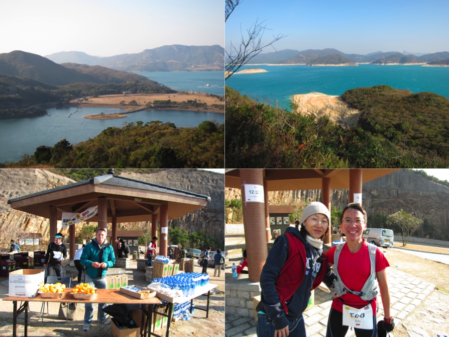
There were a total of 1 Support Point (@ 9km) and 9 Check Points (@ 18km, 28km, 36km, 45km, 52km, 65km, 73km, 82km, and 90km). My strategy was to reach CP5 before night falls, so that I could have a change of clothes, socks, shoes, as well as retrieve my torch light for the night segment of the run. The first 9km was pretty easy although there were some slopes. The trail was more of like dirt track (I hoped I got the term right since I was still pretty new to the use of proper trail running terms) while the rest were mostly on tarmac road. Just before I reached the Support Point, I removed my long-sleeved running top as I was sweating in the strong sun. At 9.40am, I arrived at Support Point after running for 9km - 1hr 40mins!
Distance covered: 9km; Time taken: 1hr 40mins
Distance covered: 9km; Time taken: 1hr 40mins
***************
Before I set off for CP1, I asked the RD - Janet, if the weather condition would be still as windy and she assured me it would be better once I cleared the next mountain. I took a banana and some water before setting off. The stretch up the mountain was manageable. Up at the highest point, the wind was so windy that it blew off my cap! Unfortunately it landed quite a distance away in the shrubs and I was unable to retrieve it back. :( After coming down from the mountain on a pavement, I ran through a series of two beaches. The sky was clear and the sea was blue! It was a very beautiful sight and I just had to stop to take in the sights. I also passed and gotten passed by other runners. Just before CP1, I walked across yet another beautiful beach before crossing a small pond. At 11:29am, about 1hr 49mins and 9km from Support Station 1, I arrived at CP1. :) I had a quick bite and water, thanked the volunteers at the aid station before continuing my journey - another 82km to the finishing line!
Distance covered: 18km; Time taken: 3hrs 29mins


***************
The distance from CP1 to CP2 was approximately 10km. Out from the CP1 aid station, the trail became rooty. I wasn't able to run. But once I reached the top, I saw yet another beach appearing right in front of my eyes! I quickened my pace during the descent and reached the beach as fast as I could. The sand was soft and made running hard. So I allowed myself to fast walk along the beach and admired the waves crashing into it. At 12:53pm, I completed the 10km route in 1hr 24mins. (Afternote: it didn't feel as though it was a 10km distance from CP1, judging from my timing clocked. But it could also be due to gentler and easier terrain during this stretch of the course.) At the aid station, I took some cut oranges, a banana and a new bottle of water before making a quick exit towards CP3. Distance remaining: 72km! Time remaining: 27hours!
Distance covered: 28km; Time taken: 4hrs 53mins
 ***************
Distance to CP3 was around 8km. So far, I felt ok with my effort. The weather was really nice although the sun was shining brightly. There were some ups and downs but nothing technical. I was really enjoying myself running alone, without anyone to push me. Then I came across yet another beach! It must have been the 4th beach I strolled across that day! When I reached the other side of the beach, things became difficult as I didn't see any course marking after climbing up several big rocks. After about 50m or so, I decided to go back to the beach to survey if I had missed any course marking. I couldn't see any but saw a runner approaching the rocks. "I should be on the right track then". I assured myself and carried on my journey. Soon, the course led me up a series of steps. It was impossible to run at all. So I took one step and a time. Although I was good at climbing stairs, this was no fun. I lost count of the time and distance. At 14:37pm, I saw CP3 course marking! This part of the course was only 8km but it took me 1hr 44mins. Must have been all those stairs! :p
Distance covered: 36km; Time taken: 6hrs 37mins

***************
The volunteers made you feel like a VIP! Once I checked-in, they invited me to sit down and asked me what I want for food. I asked for a plate of beehoon (I think). After finishing, I grabbed a bottle of water, thanked the volunteer, before setting off for CP4, which was 9km away. I walked for about 10mins as my stomach was full. Along the way, saw a few little puppies wondering on the side of the pavement. I couldn't really recall this part of the course except that there were more steps to climb! I reached CP4 at 16:18pm, after 9km and 1hr 41mins.
Distance covered: 45km; Time taken: 8hrs 18mins

***************
At CP4, the volunteers were as enthusiastic as those in CP3! One of them asked me immediately what I would like to eat and drink. And before I could even think about it, she listed down the food they had at the aid station! I politely asked for a cup of miso soup as it would be getting dark and cool. I also ate a piece of cake, 1/8 of an orange and 1 banana. CP5 is 7km away and I was confident I should reach the CP before dark. :) But I was almost wrong! I started off in an easy pace. The trail was easy. But soon, I reached the foot of a mountain. It was steep and very rocky. I tried not to look up but took consistent pace and short steps, one step at a time. Occasionally, I stopped to take photos and enjoy the views, which I probably would never see again. Due to the tougher terrain, I took 1hr 49mins to complete the 7km route before reaching CP5 - the station with my drop bag and change of gears. And at 18.07pm, it was already dark, unlike in Singapore.
Distance covered: 52km; Time taken: 10hrs 07mins

***************
The first thing I did upon reaching CP5 was to retrieve my drop bag. I took out two packets of foot powder, emptied almost the entire packet each onto my foot. I also changed to a new pair of socks and poured the remaining powder into my shoes. After taking care of my feet, I took my headlamp, wore back my long-sleeved running tee before getting a cup noodle. Unfortunately, the volunteers at the aid station must have been overworked and most of them looked tired and uninterested. I even had to ask for hot water to cook my own cup noodle! Nevertheless, I thanked them before I leave for CP6, 13km away.
I decided to take this route to the next CP very easy as it was already dark. Unlike running in the dark in Singapore, running/walking in a foreign place at night was more fun since I wouldn't know what to expect. I was totally alone, walking upslope on a tarmac road. Soon, the road led me into the trail. I switched on my headlamp once in a while to make sure that I was on the trail. Suddenly, a female voice shouted at my direction: "Are you doing the Hong Kong 100km Trail?" Hmmmm, I thought the voice sounds familiar and I was not wrong! Apparently, Chantel was unable to locate the course marking in the dark and had been lost for about 20mins. I told her I didn't see any course marking but based on my limited experience, we just need to go straight until we encounter any junction. "Surely there would be course marking" I told her. But I was wrong.
Luckily for us, there was a local Hong Kong runner just behind us just before we reached the junction. I saw the "Maclehose Trail" sign at the junction and remarked that we perhaps should turn left into the trail. The local runner confirmed that we should turn into the Maclehose Trail. The route to CP6 was really tough. There were a lot of stairs to climb up and down, but mostly up. The weather was also getting very very windy. On the way up, I would power past Chantel until I couldn't see her headlamp. Then I would wait for her by taking a rest until she caught up with me. At one point, I told her that I lost my cap as it was blown away by the strong wind in the morning. She offered me her spare one and finally, I was able to have something to cover my head! We must have walked along the ridge of the mountain as the wind was so strong and you felt that it could blow you away anytime!
We tried to navigate that portion of the route as fast as we could, as it was getting unbearably cold even though I was wearing 3 pieces of clothing and gloves. By then the local Hong Kong runner was long gone. We didn't reach CP6 until 22:26pm, a good 4hrs 19mins to traverse 13km - the toughest portion of the course!
Distance covered: 65km; Time taken: 14hrs 26mins

***************
We literally dashed into the tent upon reaching CP6. A young boy asked us what we need and we asked for a cup noddle and miso soup! In this cold weather, anything hot was preferred. In fact, it was so nice sitting and resting there that I wished the race had ended. After resting and refuelling for about 20mins, we decided to push on. Distance to CP7 was 8km away. We thanked the volunteers before continuing our race. This part of the course was rather "easy" in that it was on the tarmac road. However, it was a steep downslope so we decided to walk. Once in a while, we would look out for course marking to make sure we were on the right track. Soon, we saw a course marking that led us back into the trail.
Again like the route to CP6, there were a lot of steps to climb. By then, I realised that the batteries on my headlamp were running very low. I tried to conserve the battery by relying on Chantel's headlamp. Without her and her light, I would have been lost in the dark. The wind was not as strong as before though the weather was still cool. This was probably because we were on the other side of the mountain. During the ascent, I would powered up ahead, while on the descent and the flat terrain, Chantel would catch up with me with ease. At one of the ascent, I realised I had reached CP7 at 1.15am, Sunday morning! It took me 2hrs 49mins to cover 8km in the dark!
Distance covered: 73km; Time taken: 17hrs 15mins

***************
There were two runners in the tent at CP7 and a volunteer manning the aid station. I requested for a cup of miso soup to keep myself warm from the volunteer. About 5mins later, Chantel came into CP7. We rest for a while before setting off for CP8, which is approximately 9km away. Judging at the speed we went, I was confident that we should be able to complete the race within the cut-off time to qualify for the buckle of 24 hours.
Our spirits were high although we were both very tired and getting a little sleepy. After 2 hours inside the trail, we came to road. There were 2 marshallers and one of them pointed to us to use the overhead bridge! We followed the instructions. Upon coming down from the overhead bridge, we saw this path with a big red/white tape across that tie onto a signboard (or lamp post). We presumed that it meant we had to go straight instead of going into the small path. After walking about 1 1/2 hours, we noticed that we didn't see any other runners. Not that we saw any runners while inside the trail but somehow, we had this hunch that we were on the wrong track since we should be going into some trail instead of along a main road. At the sight of a Shell petrol station, we went inside to enquire if the road would lead us to this damn. (Luckily, Chantel carried with her a paper of the names of all check-points and the name of CP8 was Shing Mun Dam. Unfortunately, both uncles manning the petrol station were not sure although one of them pointed to us that if we continue for another hour or so, we would come to a dam whose name sounded like Shing Mun Dam.
We thanked them and proceed. However, after about 20mins, we were quite sure that we were on the wrong track as there were simply no pavement to walk further. We had in fact, come to a highway! We took our chance and ran across the road to yet another petrol station. The uncle at Esso had not heard about Shing Mun Dam before but confirmed that there was a dam if we continued in the same direction. To play safe, he offered to called the local police for help. After waiting for about 20mins, a van with 3 policemen and 1 policewoman arrived at the station. They used their Street Directory to show us where the dam was. But we were too excited to ask them about the use of pavement to the dam. By then, it was too late as they left the petrol station.
I bought two cans of hot coffee to drink and keep myself warm. After thanking the uncle for his assistance, Chantel and I went out onto the road. I whipped out my cellphone and managed to contact the RD, Janet! She wasn't sure about our location and had to pass the phone to Steve. After confirming with Steve that we were indeed on the wrong track, I seeked his permission to take cab to the overhead bridge - the last known point before we got lost. He agreed to our request. By the time the cab took us to the overhead bridge, it was almost 5am! We were lost for more than 2 hours! :( This time, we only saw one marshaller at the road side. We told him we were lost and clarified with him exactly where to turn after the overhead bridge. It was the first left turn - he said. We sighed. Somehow, we must have missed the course marking. We told him that we would not be using the overhead bridge as we already lost precious time.
Before he could say no, we ran over to the other side of the road. This time, Chantel and I walked slowly, looking for the course marking for confirmation. Finally, we saw it! It was not the normal course marking but a tiny piece of reflective ribbon tied onto a lamp post! No wonder we missed it! We were relieved yet upset. We powered forward, looking for more course marking to ensure we were on the right track, but we shouldn't worry as it was the only way to the dam. By then, we saw groups of local. They looked as though they were on their way to some morning exercises, judging from the way they dressed and their conversation. Some of them were very friendly and greeted us "good morning" in cantonese! At one point, we stopped to ask if there was a dam further up. We were glad to hear their positive response. Shortly after 6am, at 06:19am to be exact, we finally reached CP8 after 5hrs 4mins on the road/trail, including getting lost for more than 2 hours!!!
Distance covered: 82km; Time taken: 22hrs 19mins

***************
The volunteers at CP8 were very enthusiastic and happy to see us. We also met Chantel's friend at the CP. He was surprised that we were behind him. Chantel told him our ordeal. The volunteers brought us food and drink. I didn't had much as I felt abrasion at my waist after wearing the hydration bag for almost a day. Chantel's friend advised that I should apply generous helping of vaseline and one of the volunteers, upon hearing it, quickly brought me the vaseline! I applied a generous helping as advised and asked if any one had some AA size batteries for my headlamp. Immediately, the in-charged person (she seemed to be the most senior) said she had and went off to retrieve the batteries. She came back in a short file with the batteries, which I changed. In that instant, my headlamp came to life immediately, shining through the darkness! I thanked everyone at the aid station, before setting off with Chantel and her friend. Our target is CP9, 8km away.
With the newly powered headlamp, I was in high spirit. I urged Chantel and her friend to press on. We came to more steps to climb which I decided to press ahead, knowing that Chantel would surely catch up in the descent. The sky was also getting brighter with each minute passed. Luckily, this part of the steps were more gentle. But my relieve were short lived as Needle Hill came into my view. Don't be mislead. Needle Hill was more than just a hill, although it couldn't be termed as a mountain. It was steep and about 532m above sea-level. Okie, it was not that tough but after you had been running and walking for almost 24 hours, that was a tough climb! What kept me going was that I knew there would be beautiful scenery at the top of the hill and I was right. I didn't take me long before I summit.

I decided to wait for Chantel. After about 8mins, she finally reached the top of Needle Hill! We took some photos and continued our journey. As the weather was cold at the top of the hill, I sped down the hill to get out of the wind. By the time I reached the bottom of the hill, my quads were totally trashed. :( Somehow, I found my second wind and fast marched as quickly as I could, since that part of the route was mainly tarmac road. After more than an hour, I finally saw a familiar course marking! What a relief! :p After more turns and more course markings, I heard the sound of generators running and quickened my pace. I was right! I had finally reached CP9 at 08:56am: 8km in 2hrs 37mins.
Distance covered: 90km; Time taken: 24hrs 56mins

***************


Before I set off for CP1, I asked the RD - Janet, if the weather condition would be still as windy and she assured me it would be better once I cleared the next mountain. I took a banana and some water before setting off. The stretch up the mountain was manageable. Up at the highest point, the wind was so windy that it blew off my cap! Unfortunately it landed quite a distance away in the shrubs and I was unable to retrieve it back. :( After coming down from the mountain on a pavement, I ran through a series of two beaches. The sky was clear and the sea was blue! It was a very beautiful sight and I just had to stop to take in the sights. I also passed and gotten passed by other runners. Just before CP1, I walked across yet another beautiful beach before crossing a small pond. At 11:29am, about 1hr 49mins and 9km from Support Station 1, I arrived at CP1. :) I had a quick bite and water, thanked the volunteers at the aid station before continuing my journey - another 82km to the finishing line!
Distance covered: 18km; Time taken: 3hrs 29mins


The distance from CP1 to CP2 was approximately 10km. Out from the CP1 aid station, the trail became rooty. I wasn't able to run. But once I reached the top, I saw yet another beach appearing right in front of my eyes! I quickened my pace during the descent and reached the beach as fast as I could. The sand was soft and made running hard. So I allowed myself to fast walk along the beach and admired the waves crashing into it. At 12:53pm, I completed the 10km route in 1hr 24mins. (Afternote: it didn't feel as though it was a 10km distance from CP1, judging from my timing clocked. But it could also be due to gentler and easier terrain during this stretch of the course.) At the aid station, I took some cut oranges, a banana and a new bottle of water before making a quick exit towards CP3. Distance remaining: 72km! Time remaining: 27hours!
Distance covered: 28km; Time taken: 4hrs 53mins

Distance to CP3 was around 8km. So far, I felt ok with my effort. The weather was really nice although the sun was shining brightly. There were some ups and downs but nothing technical. I was really enjoying myself running alone, without anyone to push me. Then I came across yet another beach! It must have been the 4th beach I strolled across that day! When I reached the other side of the beach, things became difficult as I didn't see any course marking after climbing up several big rocks. After about 50m or so, I decided to go back to the beach to survey if I had missed any course marking. I couldn't see any but saw a runner approaching the rocks. "I should be on the right track then". I assured myself and carried on my journey. Soon, the course led me up a series of steps. It was impossible to run at all. So I took one step and a time. Although I was good at climbing stairs, this was no fun. I lost count of the time and distance. At 14:37pm, I saw CP3 course marking! This part of the course was only 8km but it took me 1hr 44mins. Must have been all those stairs! :p
Distance covered: 36km; Time taken: 6hrs 37mins

The volunteers made you feel like a VIP! Once I checked-in, they invited me to sit down and asked me what I want for food. I asked for a plate of beehoon (I think). After finishing, I grabbed a bottle of water, thanked the volunteer, before setting off for CP4, which was 9km away. I walked for about 10mins as my stomach was full. Along the way, saw a few little puppies wondering on the side of the pavement. I couldn't really recall this part of the course except that there were more steps to climb! I reached CP4 at 16:18pm, after 9km and 1hr 41mins.
Distance covered: 45km; Time taken: 8hrs 18mins

At CP4, the volunteers were as enthusiastic as those in CP3! One of them asked me immediately what I would like to eat and drink. And before I could even think about it, she listed down the food they had at the aid station! I politely asked for a cup of miso soup as it would be getting dark and cool. I also ate a piece of cake, 1/8 of an orange and 1 banana. CP5 is 7km away and I was confident I should reach the CP before dark. :) But I was almost wrong! I started off in an easy pace. The trail was easy. But soon, I reached the foot of a mountain. It was steep and very rocky. I tried not to look up but took consistent pace and short steps, one step at a time. Occasionally, I stopped to take photos and enjoy the views, which I probably would never see again. Due to the tougher terrain, I took 1hr 49mins to complete the 7km route before reaching CP5 - the station with my drop bag and change of gears. And at 18.07pm, it was already dark, unlike in Singapore.
Distance covered: 52km; Time taken: 10hrs 07mins

The first thing I did upon reaching CP5 was to retrieve my drop bag. I took out two packets of foot powder, emptied almost the entire packet each onto my foot. I also changed to a new pair of socks and poured the remaining powder into my shoes. After taking care of my feet, I took my headlamp, wore back my long-sleeved running tee before getting a cup noodle. Unfortunately, the volunteers at the aid station must have been overworked and most of them looked tired and uninterested. I even had to ask for hot water to cook my own cup noodle! Nevertheless, I thanked them before I leave for CP6, 13km away.
I decided to take this route to the next CP very easy as it was already dark. Unlike running in the dark in Singapore, running/walking in a foreign place at night was more fun since I wouldn't know what to expect. I was totally alone, walking upslope on a tarmac road. Soon, the road led me into the trail. I switched on my headlamp once in a while to make sure that I was on the trail. Suddenly, a female voice shouted at my direction: "Are you doing the Hong Kong 100km Trail?" Hmmmm, I thought the voice sounds familiar and I was not wrong! Apparently, Chantel was unable to locate the course marking in the dark and had been lost for about 20mins. I told her I didn't see any course marking but based on my limited experience, we just need to go straight until we encounter any junction. "Surely there would be course marking" I told her. But I was wrong.
Luckily for us, there was a local Hong Kong runner just behind us just before we reached the junction. I saw the "Maclehose Trail" sign at the junction and remarked that we perhaps should turn left into the trail. The local runner confirmed that we should turn into the Maclehose Trail. The route to CP6 was really tough. There were a lot of stairs to climb up and down, but mostly up. The weather was also getting very very windy. On the way up, I would power past Chantel until I couldn't see her headlamp. Then I would wait for her by taking a rest until she caught up with me. At one point, I told her that I lost my cap as it was blown away by the strong wind in the morning. She offered me her spare one and finally, I was able to have something to cover my head! We must have walked along the ridge of the mountain as the wind was so strong and you felt that it could blow you away anytime!
We tried to navigate that portion of the route as fast as we could, as it was getting unbearably cold even though I was wearing 3 pieces of clothing and gloves. By then the local Hong Kong runner was long gone. We didn't reach CP6 until 22:26pm, a good 4hrs 19mins to traverse 13km - the toughest portion of the course!
Distance covered: 65km; Time taken: 14hrs 26mins

We literally dashed into the tent upon reaching CP6. A young boy asked us what we need and we asked for a cup noddle and miso soup! In this cold weather, anything hot was preferred. In fact, it was so nice sitting and resting there that I wished the race had ended. After resting and refuelling for about 20mins, we decided to push on. Distance to CP7 was 8km away. We thanked the volunteers before continuing our race. This part of the course was rather "easy" in that it was on the tarmac road. However, it was a steep downslope so we decided to walk. Once in a while, we would look out for course marking to make sure we were on the right track. Soon, we saw a course marking that led us back into the trail.
Again like the route to CP6, there were a lot of steps to climb. By then, I realised that the batteries on my headlamp were running very low. I tried to conserve the battery by relying on Chantel's headlamp. Without her and her light, I would have been lost in the dark. The wind was not as strong as before though the weather was still cool. This was probably because we were on the other side of the mountain. During the ascent, I would powered up ahead, while on the descent and the flat terrain, Chantel would catch up with me with ease. At one of the ascent, I realised I had reached CP7 at 1.15am, Sunday morning! It took me 2hrs 49mins to cover 8km in the dark!
Distance covered: 73km; Time taken: 17hrs 15mins

There were two runners in the tent at CP7 and a volunteer manning the aid station. I requested for a cup of miso soup to keep myself warm from the volunteer. About 5mins later, Chantel came into CP7. We rest for a while before setting off for CP8, which is approximately 9km away. Judging at the speed we went, I was confident that we should be able to complete the race within the cut-off time to qualify for the buckle of 24 hours.
Our spirits were high although we were both very tired and getting a little sleepy. After 2 hours inside the trail, we came to road. There were 2 marshallers and one of them pointed to us to use the overhead bridge! We followed the instructions. Upon coming down from the overhead bridge, we saw this path with a big red/white tape across that tie onto a signboard (or lamp post). We presumed that it meant we had to go straight instead of going into the small path. After walking about 1 1/2 hours, we noticed that we didn't see any other runners. Not that we saw any runners while inside the trail but somehow, we had this hunch that we were on the wrong track since we should be going into some trail instead of along a main road. At the sight of a Shell petrol station, we went inside to enquire if the road would lead us to this damn. (Luckily, Chantel carried with her a paper of the names of all check-points and the name of CP8 was Shing Mun Dam. Unfortunately, both uncles manning the petrol station were not sure although one of them pointed to us that if we continue for another hour or so, we would come to a dam whose name sounded like Shing Mun Dam.
We thanked them and proceed. However, after about 20mins, we were quite sure that we were on the wrong track as there were simply no pavement to walk further. We had in fact, come to a highway! We took our chance and ran across the road to yet another petrol station. The uncle at Esso had not heard about Shing Mun Dam before but confirmed that there was a dam if we continued in the same direction. To play safe, he offered to called the local police for help. After waiting for about 20mins, a van with 3 policemen and 1 policewoman arrived at the station. They used their Street Directory to show us where the dam was. But we were too excited to ask them about the use of pavement to the dam. By then, it was too late as they left the petrol station.
I bought two cans of hot coffee to drink and keep myself warm. After thanking the uncle for his assistance, Chantel and I went out onto the road. I whipped out my cellphone and managed to contact the RD, Janet! She wasn't sure about our location and had to pass the phone to Steve. After confirming with Steve that we were indeed on the wrong track, I seeked his permission to take cab to the overhead bridge - the last known point before we got lost. He agreed to our request. By the time the cab took us to the overhead bridge, it was almost 5am! We were lost for more than 2 hours! :( This time, we only saw one marshaller at the road side. We told him we were lost and clarified with him exactly where to turn after the overhead bridge. It was the first left turn - he said. We sighed. Somehow, we must have missed the course marking. We told him that we would not be using the overhead bridge as we already lost precious time.
Before he could say no, we ran over to the other side of the road. This time, Chantel and I walked slowly, looking for the course marking for confirmation. Finally, we saw it! It was not the normal course marking but a tiny piece of reflective ribbon tied onto a lamp post! No wonder we missed it! We were relieved yet upset. We powered forward, looking for more course marking to ensure we were on the right track, but we shouldn't worry as it was the only way to the dam. By then, we saw groups of local. They looked as though they were on their way to some morning exercises, judging from the way they dressed and their conversation. Some of them were very friendly and greeted us "good morning" in cantonese! At one point, we stopped to ask if there was a dam further up. We were glad to hear their positive response. Shortly after 6am, at 06:19am to be exact, we finally reached CP8 after 5hrs 4mins on the road/trail, including getting lost for more than 2 hours!!!
Distance covered: 82km; Time taken: 22hrs 19mins

The volunteers at CP8 were very enthusiastic and happy to see us. We also met Chantel's friend at the CP. He was surprised that we were behind him. Chantel told him our ordeal. The volunteers brought us food and drink. I didn't had much as I felt abrasion at my waist after wearing the hydration bag for almost a day. Chantel's friend advised that I should apply generous helping of vaseline and one of the volunteers, upon hearing it, quickly brought me the vaseline! I applied a generous helping as advised and asked if any one had some AA size batteries for my headlamp. Immediately, the in-charged person (she seemed to be the most senior) said she had and went off to retrieve the batteries. She came back in a short file with the batteries, which I changed. In that instant, my headlamp came to life immediately, shining through the darkness! I thanked everyone at the aid station, before setting off with Chantel and her friend. Our target is CP9, 8km away.
With the newly powered headlamp, I was in high spirit. I urged Chantel and her friend to press on. We came to more steps to climb which I decided to press ahead, knowing that Chantel would surely catch up in the descent. The sky was also getting brighter with each minute passed. Luckily, this part of the steps were more gentle. But my relieve were short lived as Needle Hill came into my view. Don't be mislead. Needle Hill was more than just a hill, although it couldn't be termed as a mountain. It was steep and about 532m above sea-level. Okie, it was not that tough but after you had been running and walking for almost 24 hours, that was a tough climb! What kept me going was that I knew there would be beautiful scenery at the top of the hill and I was right. I didn't take me long before I summit.

I decided to wait for Chantel. After about 8mins, she finally reached the top of Needle Hill! We took some photos and continued our journey. As the weather was cold at the top of the hill, I sped down the hill to get out of the wind. By the time I reached the bottom of the hill, my quads were totally trashed. :( Somehow, I found my second wind and fast marched as quickly as I could, since that part of the route was mainly tarmac road. After more than an hour, I finally saw a familiar course marking! What a relief! :p After more turns and more course markings, I heard the sound of generators running and quickened my pace. I was right! I had finally reached CP9 at 08:56am: 8km in 2hrs 37mins.
Distance covered: 90km; Time taken: 24hrs 56mins

After checking-in, I took shelter in the tent. I met another runner who had to DNF for good as he had some injury. Chantel arrived at the CP about 6 mins later and we both set off for the last part of the race. As we trekked up the summit, we met some hikers who stayed the night at the summit. Chantel asked them about the mountain which we were heading to. One of the hikers pointed to another mountain. It was so near yet, sooooooo far!!! :( Luckily, this part of the race was very scenic. I was glad that I could witness the beauty of the mountains in daylight instead of in the dark. We also had to manoeuver around big boulders. Soon, I forged ahead but occasionally I would turn back to take a picture of Chantel and the scenery. Every step I took seemed to bring the mountain that we are heading a little closer. Soon, I seemed to reach bottom of the final mountain but there was no course markings to be seen. I decided that since there was no other way to go except the road up, I should e on the right track.
By then, I had stopped running. Even after I reached the final summit and on my way down, I just didn't have the energy to lift up my legs. In fact, I had to use much energy to balance myself while threading down the steep downhill carefully. On my way down, I saw many locals walking up the mountain - most of them along the same road I took coming down, while some bashed through it. Since there were still no signs of the course markings, I asked one of the local if the Rotary Club Park was at the end of the road and if there were any other way down. He must be wondering why would someone asked him such a hilarious question but the local nodded politely that the road was indeed the only way down to the Rotary Club Park (so I was on the right track) and the other way of going down was to take short-cut by bashing through the plants next to the road. I thanked him and pushed on.
I finally saw the course marking! The section that I had just completed seemed to be reserved for hikers as there was a chain across the path. A small parking lot next to the path seemed to confirmed my suspicion. No wonder there were no cars! The further I walked, the more excited I became. I saw road signs that showed that the Rotary Club Park. I looked at my watch and thought that I might just make it within 28 hours! I needn't have to worry although I almost missed the left turn into the car park area of the Rotary Club Park! Luckily, the RD had decorated the finishing line with colorful papers that were hard to miss. I eventually crossed the line at 11:55am (10km in 2hrs 59mins), after covering 100km in 27hrs 55mins! Chantel also beat the 28 hour mark by crossing the line just 4mins later! We were both ecstatic but tired. The RDs, Janet & Steve, presented us our finisher sweater and certificate. Although I didn't get the finisher trophy, given to those who completed in less than 24 hours, I was happy with my effort as this was the first 100km trail race that I had completed within the cut-off time set by the official. :)
Distance covered: 100km; Time taken: 27hrs 55mins

***************
Afternote: I enjoyed myself throughout the race. The weather was almost perfect for me, less the strong wind that made the night portion of the race more challenging. The volunteers at most aid stations were enthusiastic and encouraging. Although I was upset at the time lost due to making the wrong turn, I was grateful to the locals for being so helpful. My other positives take away are: having no blisters at the end of the race and able to finish the race strong. :) Would I recommend this race to anyone? Yes, but only if the person enjoys trail. At the same time, I would also warn the person that there were a lot of "unnatural" steps in the trail, which made the ascending and descending easy (to manoeuvre) and hard (due to the pounding on the knees, especially when you were going down).

5 comments:
came across your blog.. you going to do it next year?
halo jogger joel... nope... once is enough... there are many trails around the world waiting for me to explore... :)
Thanks for sharing.
Thanks for sharing.
Post a Comment